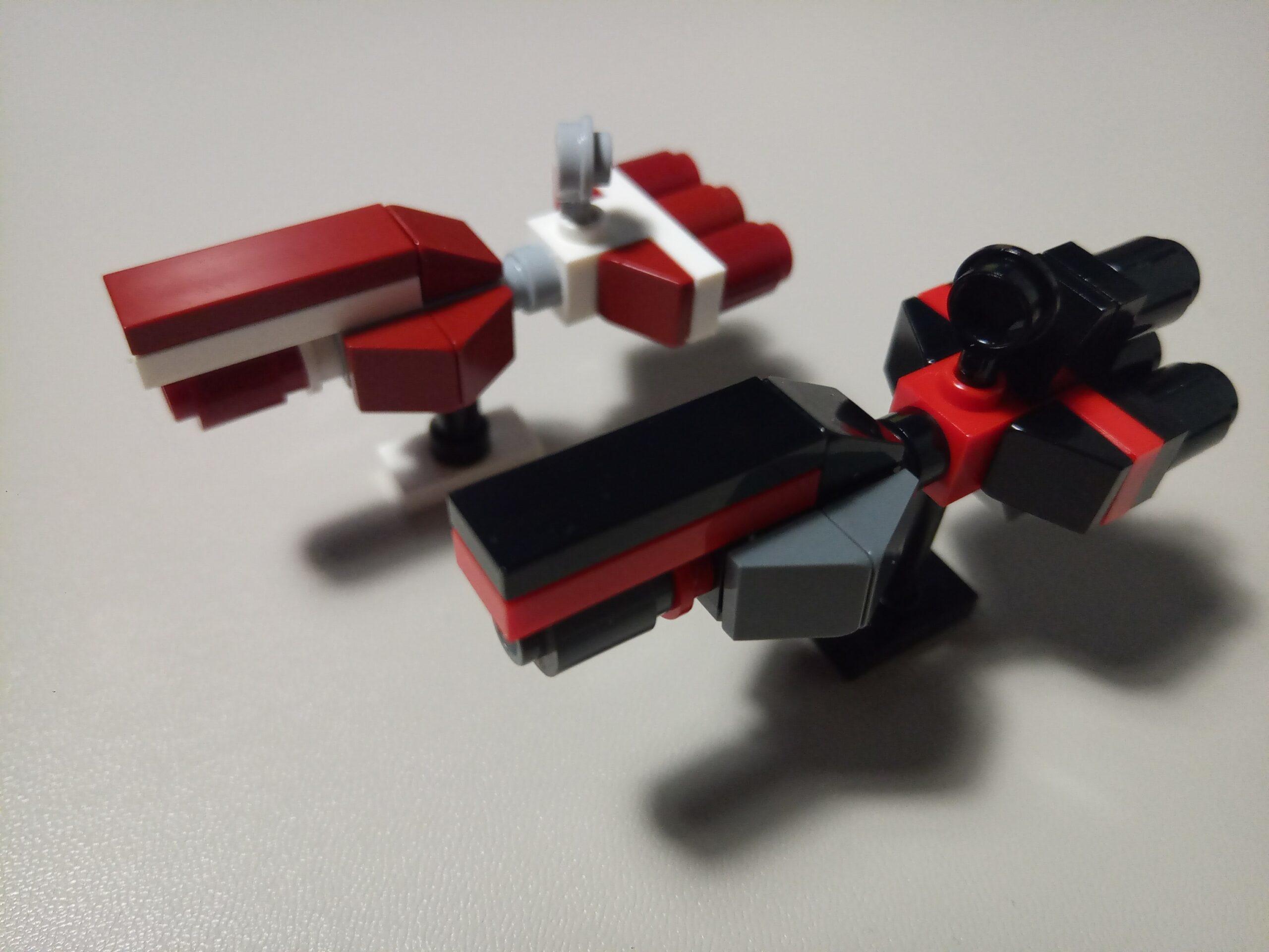
Olav’s Wood walk

Olav’s Wood is a cultivated woodland on Orkney that was started by Olav Dennison in the 1970s and is still being developed.

Entrance to Olav's Wood

There are a variety of trees, especially in the upper part of the wood near the entrance, and there a numerous paths that wander round this area.

Path in Olav's Wood

The path continues down alongside and over Oback burn.

Bridge over Oback Burn in Olav's Wood

Further down is an area of evergreen trees.

Path in Olav's Wood

The path then rejoins the burn.

Walkway in Olav's Wood

Oback Burn in Olav's Wood

Next to the south end of the woodland is an area that has been planted with dog roses.

Dog roses at Olav's Wood

Rose hips in Olav's Wood

Continue reading “Olav’s Wood walk”


Yesnaby Cliffs Walk

The Yesnaby cliffs are a popular tourist spot on Orkney, probably because there’s a road that leads up to it and a decent sized car park that is the firing point of the World War II anti-aircraft firing range.

Yesnaby carpark showing AA gun mounting points

The circular mounting points for the AA guns can clearly be seen in the concrete and crews from ships moored in Scapa Flow would come here to practice firing at targets towed by aircraft (including Defiants, Skuas, Martinets and Cheaspeaks) based at H.M.S. Tern (R.N.A.S. Twatt).

Yesnaby carpark showing AA gun mounting points

Near the carpark is the Brough of Bigging which is a promontory which has views from Hoy to Marwick Head.

Panorama from Brough of Bigging showing Hoy to Marwick Head

Further on there is the Castle of Qui Ayre, an arch that is still – just – attached to the cliffs.

Castle of Qui Ayre

On the other side of this is the stack known as Yesnaby Castle.

Yesnaby Castle

Waking further round this back the path heads up hill along the edge of Inga Ness and becomes significantly less trafficked, it’s obvious that the vast majority of visitors don’t venture much past Yesnaby Castle.

Yesnaby Castle and Garthna Geo

Further along the cliffs past Inga Ness is Harra Ebb where the cliff tops slope down more gently to the sea.  There were a number of seals round the rocks here.

Harra Ebb

Next is the point of Lyregeo which features an impressive cave.  This coast line is a great example of a school geography lesson with the tag line “cracks, caves, arches, stacks and stumps” which are the stages of erosion on this kind of coast.

Point of Lyre Geo

At the furthest point we walked to (and had our lunch before turning back) is North Gaulton Castle which was used for a Rover advert.

North Gaulton Castle

Continue reading “Yesnaby Cliffs Walk”


Brough of Birsay walk

The Brough of Birsay is an island that is reached via a tidal causeway from the Point of Buquoy on Mainland.  The name derives from the Norse Byrgisey meaning “fortress island”.

Brough of Birsay and causeway

Arriving on the island from the causeway there is a Norse settlement dating from the 10th and 11th centuries and a church and monastery from the 12th century.

Birsay settlement and church

Walking round the edge of the islands there are some vertiginous cliffs with deep clefts home to many seabirds.

Cliffs on the Brough of Birsay Cliffs on the Brough of Birsay Cliffs on the Brough of Birsay Cliffs on the Brough of Birsay Cliffs on the Brough of Birsay

There were plenty of seals visible from the cliffs and I’m beginning to suspect my companion is a selkie as she even managed to spot one swimming under the surface.

At the north west of the island is the lighthouse on Brough Head.   This was built by David Alan Stephenson in 1925.

Birsay lighthouse

Views from here go from Marwick Head to Rousay

Marwick Head and Atlantic Brough Head and lighthouse

Returning back towards the causeway the rest of the panorama can be viewed.

Point of Buquoy to Marwick Head

Back on mainland the walk continues round the coast to Skiba Geo and its boat nousts, recesses dug into the in the cliff tops where fishing boats were stored over winter.

Skiba Geo boat nousts

At the headland on the far side of the bay is a whale’s vertebrae mounted on a rib at the end of the 19th century, possibly as a fisherman’s marker.  It is known simply as The Whalebone.

Skiba Geo

Continue reading “Brough of Birsay walk”


Orphir walk

Mentioned in the 1136 Orkneyinga saga the Orphir circular Kirk is the last remaining circular church in Scotland. The plan is said to be inspired by the rotunda of the Holy Sepulcher in Jerusalem which was increasingly visited by pilgrims following the capture of the Holy Land in the first Crusade. One of these was Earl Hakon who traveled there to atone for ordering the death of St. Magnus on Egilsay in about 1116. The Orphir Kirk may have been built after his return and before his death in about 1123.

Orphir round kirk Orphir round kirk

The St Magnus trail follows the coast round the north shore of Scapa Flow.

Shoreline near Orphir

The wall round the edge of the field has a heavy covering of lichen.

Lichen on a stone

Further along the headland are a pair of fishermans’ cottages.

Fishermen's huts

The tip of the headland looks out onto the stretch of water where on 5th August 1917 Squadron Commander Edwin Dunning became the first person to land a plane on a moving ship.  Taking off from Smoogro in a Sopwith Pup he landed on the flying off deck of HMS Furious dodging the funnels and the turbulence they produced.  Well before the invention of arrester wires a grappling party of the ship’s deck hands grabbed hold of ropes that had been attached to the plane in order to restrain it.  Unfortunately five days later he died attempting to repeat the feat when, despite the best efforts of the grappling party, his aircraft fell off the side of the deck and he drowned.

Shoreline near Orphir

Continuing along the path the coast line flattens out and there is now a fish farm close to the shore.

Shoreline near Orphir Shoreline near Orphir and fish farm offshore

Returning to the fishermens’ cottages and heading inland near Gyre farm there is a small area of woodland, very unusual for Orkney.

Gyre farm woods Gyre farm woods

Continue reading “Orphir walk”


Standing stones walk

The first set of standing stones were the Stones of Stenness.  The name comes from the Norse Stein Ness meaning stone point which suggests they have been the dominant feature of this area for most of human history as this is one of the oldest henges in the British Isles.

Stones of Stenness

Behind the stones is a settlement.  This features a large building surrounded by circular borders and the entrance to the Standing Stones faced in this direction suggesting it had some form of ceremonial significance.

Barnhouse settlement

Next to this is a building with two hearths that is constructed in a similar way to burial cairns which suggests this was also a significant, non-residential, building.  Behind this is a residential building, similar to those found at Skara Brae.

Barnhouse settlement

Following the path towards the Ring of Brodgar past the Loch of Stenness the peaks of Hoy are visible in the distance.

Loch of Stenness and Hoy

The Ring of Brodgar is a much larger stone circle that is 500-1000 years newer than the Stones of Stenness and is the third largest in the British Isles.

Ring of Brodgar Ring of Brodgar

The path returns to the Stones of Stenness and on the other side of the cuaseway that links them lies Loch Harray.

Ring of Brodgar Loch of Harray Standing Stones of Stenness

Continue reading “Standing stones walk”


Replacing 2CV axle bolts

The final item I had left on my to-do list from the re-chassis was to replace the axle bolts. Whilst doing the re-chassis we re-used the old bolts but they were showing signs of necking (although TomB engineering assessed they were within tolerance).

Old 2CV axle bolt showing necking

The bolts are held in place with lock washers which are bent over at the ends to prevent them working loose so the first step is to bend these back to get access to the bolt heads. As the bolts are what’s holding the axle to the chassis removing both at once could allow the axle to move relative to the chassis which would mean it’s no longer possible to get the thread to engage in the axle mount and, given the forces from the weight of the car and the spring tension in the suspension, it is very difficult to re-align things if they move (thus spake the voice of experience).

To avoid this it is best to replace them one at a time. To do this first loosen off both bolts just enough to free the lock washer, then take one bolt out, rotate the old lock washer out of the way then insert one new bolt and the lock washer ensuring the threads are fully engaged in the axle.

2CV axle bolts and lock washers mid-replacement

Now take out the remaining old bolt and lock washer before fitting the remaining new bolt through the lock washer.

2CV axle bolts

The bolts are then tightened up to 50 N m and, using a persuadatron and a cold chisel, the lock washers are bent around them to… well… lock them in.

2CV axle bolt with bent lock washer

For comparison, the new high tensile axle bolts and lock washers with the original bolts and washers that were used during the re-chassis.

Old and new 2CV axle bolts and lock washers

Of course, someone wasn’t too happy about the disturbance to his afternoon snooze.

Cat looking suspicious on top of a 2CV


Replacing the primary jet in a 2CV carburettor

The later models of 2CVs come with a twin choke carburettor with the primary (smaller) being used at low revs and a mechanical linkage opening the secondary (larger) as the throttle is depressed further.  Fuel is allowed into the venturi from the bowls by small brass jets (screws with calibrated holes in the middle), the size of which controls the fuel/air mixture.  As standard the primary jet is a 102.5 which, for modern fuels, is slightly undersized leading to a slight flat spot in acceleration from low revs.  To eliminate this fitting a 107 jet is recommended.

The secondary jet is easily accessible at the base of the fuel bowl but the primary is a bit more complex.   The first step is to take the top off the carburettor, with the elephant’s knee (air intake pike) removed there are six flat head screws – one of which holds the choke cable in place – and the top of the carburettor lifts off.  As the jets are at the bottom of the bowls they will need any residual petrol in them removing.

Interior of a 2CV carburettor

Now comes the tricky part.  On the back right (as you look at it when standing in front of the car) corner of the carburettor is a 12mm bolt head – this is the access port to get to the primary jet.  With that bolt removed there is now a head on approach to the primary jet – shown arrowed here:

Interior of a 2CV carburettor showing primary jet location and access

The jet has a slot cut in it for a flat head screwdriver which needs introducing through the access port.  Fortunately in my tool box I happened to have a long electricians’ screwdriver that could have been specially made for this exact job as it extended clear of all the obstructions in this area and made this job much easier than I was anticipating.

Using a long screwdriver to unscrew the primary jet from a 2CV carburettor

With the jet unscrewed it will need removing from the carburettor.  As it’s brass the traditional use of a magnetic pick-up isn’t an option so I found a cocktail stick worked well as it wedges in the middle of the jet without damaging it and holds it just enough to withdraw it.

Using a cocktail stick to remove the primary jet from a 2CV carburettor

Fitting the new jet is, of course, the reverse of removal – making sure to reconnect the choke cable when replacing the top of the carburettor.

When everything is buttoned back up check the car starts and runs – it will probably need some cranking to re-fill the carburettor bowls.  Then, when the engine is nicely up to temperature the idle will need re-setting.


Sheriff Muir Atlantic Wall test site revisited

In my first trip to the Sheriff Muir Atlantic Wall test site I didn’t explore the bunkers on either side of the sea wall section.

To the south of the wall is a blockhouse.

Blockhouse at Sheriff Muir Atlantic Wall test site viewed from the front Blockhouse at Sheriff Muir Atlantic Wall test site viewed from the rear

This is a fairly crude blockhouse, presumably because one of the quality found on the real Atlantic Wall would have been very costly to build – especially on the side of a Scottish hill – and it’s only going to be blown up anyway. The front (“seaward”) side has been extensively damaged.

Blockhouse at Sheriff Muir Atlantic Wall test site showing damage

The interior is where the crudeness of the construction is most evident.

Interior of blockhouse at Sheriff Muir Atlantic Wall test siteInterior of blockhouse at Sheriff Muir Atlantic Wall test site

Behind this there is a well concealed sunken bunker that, with a thick grass covering, looks like little more than an undulation in the ground.

Front of sunken bunker at Sheriff Muir Atlantic Wall test site

It is only when you are passed it that the rear entrance gives away its position.

Entrance to sunken bunker at Sheriff Muir Atlantic Wall test siteEntrance to sunken bunker at Sheriff Muir Atlantic Wall test siteEntrance to sunken bunker at Sheriff Muir Atlantic Wall test site

There may well have been other structures in this area as well given that there are tussocks of grass with rebar sticking out of them.

Rebar sticking out of some grass at Sheriff Muir Atlantic Wall test site

To the north of the sea wall section there is another sunken bunker, this time with a trench system leading to the rear entrance.

Access trench to bunker with Tobruk pits at Sheriff Muir Atlantic Wall test siteRear of bunker with Tobruk pits at Sheriff Muir Atlantic Wall test site

The defining feature of this bunker is the two Tobruk pits on the top. On the Atlantic Wall the Germans used these to mount turrets from captured tanks – predominantly French models – to create gun emplacements.

Tobruk pits at Sheriff Muir Atlantic Wall test siteTobruk pit at Sheriff Muir Atlantic Wall test site